It was one of the greats: The Convair 580 remote sensing aircraft of the Canada Aviation and Space Museum

Hello, good day, my reading friend. What would you think of a brief excursion into the wonderful world of aviation and space? Surprise!
This is not news to you, aviation enthusiast that you are, that it was in December 1950 that North America’s first turboprop airliner flew for the first time. Consolidated Vultee Aircraft Corporation, or Convair, worked with the Allison Division of General Motors Corporation, an American automotive giant mentioned several / many times in our blog / bulletin / thingee since March 2018, to fly said aircraft, the prototype of the Convair Model 240, renamed Turbo-Liner for the occasion. Since the version of the engine used on this aircraft was not put in production, the good performance of the Turbo-Liner had no concrete consequences.
I can see in your face the desire to know more about the Model 240 and the other members of this remarkable family of medium-range airliners, the Models 340, 440, etc. A little information on this subject being in a March 2020 issue of our blog / bulletin / thingee, may I suggest that you consult said issue?
Yours truly wishes instead to approach the career of an example of this beautiful and large family which, in its time, was known throughout the world. Said aircraft is one of the members of a large and beautiful family sheltered under the roofs of the Canada Aviation and Space Museum, an incomparable institution you will admit.
Was the flight of the Turbo-Liner in December 1950 simply a pretext to open the door to a pontification, you ask, my Sherlockian reading friend? You are totally right. I am giving myself a little before date Christmas present.
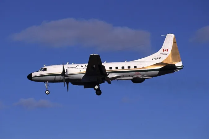
Curtain opening. Dramatic music. In April 1953, in light and noise, Convair personnel completed a Model 340. United Air Lines Incorporated took possession of this aircraft in May. In November 1958, this major American airline mentioned in March 2018 and January 2019 issues of our you know what sold the Model 340 to Johnson & Johnson Incorporated, a world-famous American pharmaceutical firm. Pacific Airmotive Corporation replaced the aircraft’s piston engines with Allison turboprop engines in 1963. Our Model 340 was then redesignated Convair 580, or Convair 580 or CV-580.
Johnson & Johnson sold the aircraft to Great Lakes Paper Company Limited of Thunder Bay, Ontario, which registered it in March 1970. Great Lakes Paper sold the Convair 580 to an American rack jobber and discount store operator which registered it in January 1973. Sav-a-Stop Incorporated sold the aircraft to Omni Investment Corporation which registered it in 1974. This American specialist in the sale of aircraft sold the Convair 580 to the Department of Energy, Mines and Resources of Canada which registered it in June 1975.
An experienced maintenance and service firm, Innotech Aviation Limited of Dorval, Québec, worked on the Convair 580 for about 2 years. A relatively small but respected firm based in Edmonton, Alberta, which specialised in subcontracting and civil and military aircraft overhaul mentioned in February, March and April 2020 issues of our blog / bulletin / thingee, completed the conversion of the Convair 580 into a remote sensing aircraft. Northwest Industries Limited completed its work in 1977.
The registration of the aircraft itself, C-GRSC, was interesting. It was chosen for its closeness to the expression Canadian remote sensing Convair. A gentleman by the name of Leon Bronstein seemingly played a real role in this choice.
By coincidence, the acronym CGRSC had a very precise meaning. It stood for Canadian Geodetic Reference System Committee, a federal provincial committee of the Canadian Council on Geomatics founded in 1981 which did not acquire its present name until 1992. Yours truly (seriously?) wonders if this name was chosen to match the registration of the Convair 580. Anyway, let’s move on.
The Canadian career of our aircraft had its origins in the creation of the Canada Centre for Remote Sensing (CCRS) in Ottawa in 1971. The researchers working there were then keen to carry out research using a high performance / high resolution radar. A number of people at CCRS suggested the use of a military synthetic aperture radar designed, manufactured and used by the Environmental Research Institute of Michigan (ERIM), an organisation funded in large part by the United States Air Force. Without belittling the contribution of these individuals, the name of the first director of CCRS, a geophysicist, Lawrence Whitaker “Larry” Morley, may stand out a tad more.
The radar system in question weighing nearly four tonnes (tons), it was necessary to find a large and long range aircraft capable of transporting it. And no, the Convair 580 was not quickly chosen. There were discussions. Some people wanted to use a Consolidated Catalina / Canso amphibian, a type of aircraft present in the collection of the Canada Aviation and Space Museum.
Mounted on an aircraft or spacecraft, a synthetic aperture radar uses the movement of its carrier to create a high resolution map of its surroundings, and this even though its antenna is relatively small.
An American engineer and mathematician, Carl Atwood Wiley, came up with the idea for such a radar in the early 1950s.
The Convair 580 began its new career in 1977-78, becoming one of the very first civil earthling aircraft used for the development of synthetic aperture radars. Then known under the designation of SAR 580 System, said radar was the property of ERIM which leased it to CCRS between 1977 and 1985 or so.
Given the interest of the federal government in promoting remote sensing, the possibility of leasing the aircraft for commercial was put forward. A Calgary, Alberta firm, Intera Technologies Limited, which had a subcontract with Innotech Aviation, promoted the idea in Canada and Europe.
Would you believe that it was in large part thanks to the Convair 580 that CCRS became a known and respected organization worldwide?
Before I forget, in 2020, CCRS was a division of the Canada Centre for Mapping and Earth Observation.
Over the years, the Convair 580 contributed to important Canadian programmes. It made numerous flights in the Canadian Arctic as early as 1978 (and until 2006?) to study the ice (movements, classification, identification of types, ship detection, etc.). Many / most of these flights took place in collaboration with the United States.
Let us mention, for example, those surrounding AIDJEX 78 (Arctic Ice Dynamics Joint Experiment 1978) and those which supported the SURSAT (SURveillance SATellite) project, a Canadian surveillance satellite programme dating from 1977-79 which had took place as Canada participated in the American Seasat programme, Seasat being one of the first civilian remote sensing satellites, successfully launched in June 1978. Both were linked to the development of the oil resources of the Beaufort Sea.
The Convair 580 also participated in MIZEX’84 (Marginal Ice Zone EXperiment 1984). This multinational and multidisciplinary programme took place in the North Atlantic, between Greenland and the Svalbard archipelago, and aimed to study the ice, waters, etc. The on-board equipment of the Convair 580, used in conjunction with ground-based processing equipment, then played a vital role in the development of methods of observing wind and waves from space, a major factor in improving weather forecasts.
Other flights to the Canadian Arctic were carried out in collaboration with Calgary-based Dome Petroleum Limited, a subsidiary of Toronto, Ontario, based Dome Mines Limited, and other firms operating there. The oil industry wanted to better understand the movement of the ice in order to reduce the risk of impacts with its drilling platforms.
The numerous flights of the Convair 580 allowed the development of new radars used both on aircraft and satellites. The first of these systems dated from 1984, for example. It was the STAR-1 (Sea ice and Terrain Assessment Radar-1) of the aforementioned Intera Technologies, developed in collaboration with ERIM and MacDonald, Dettwiler and Associates Limited (MDA), in its Richmond, British Columbia facility. All of the flights supported the work of the Canadian Ice Service, a division of the Meteorological Service of Canada, itself a branch of Environment Canada.
In 1985, the Convair 580 received a new synthetic aperture radar, the CCRS’ C/X-SAR.
SAREX’92 (South American Radar EXperiment 1992) was a joint programme of CCRS, the Canadian International Development Agency and the European Space Agency (ESA). It provided a great deal of data on the management of tropical forests in Latin America (Brazil, Colombia, Costa Rica, French Guyana, Guyana and Venezuela).
The 1993 GlobeSAR programme, on the other hand, was a Canadian programme which brought together CCRS, the Canadian Space Agency (CSA), the International Development Research Centre and RADARSAT International Incorporated, a Canadian firm created by a consortium which included MDA.
And yes, the CSA was mentioned several times in our blog / bulletin / thingee since December 2017.
GlobeSAR acquired a considerable amount of data while simulating the type of data that would subsequently be provided by RADARSAT (RADAR SATellite), today’s RADARSAT-1, the first Canadian remote sensing satellite, launched in November 1995. The Convair 580 then flew over more than around 10 countries in Africa (Kenya, Morocco, Tanzania, Tunisia and Uganda) and Asia (China, Jordan, Malaysia, Taiwan, Thailand and Vietnam).
In addition to being very successful, SAREX’92 and GlobeSAR led several developing countries to build useful remote sensing capabilities. The Canadian aerospace industry took advantage of this situation by selling millions of dollars in equipment (radar systems, satellite data receiving stations, systems to transform data into imagery, etc.) to the countries in question.
Did you know that the $ 100 Canadian Journey series banknote released in 2004 had / has a picture of RADARSAT-1 on the back? But I digress, sorry.
It should be noted that the Convair 580 was the very first aircraft equipped with sophisticated detection equipment to be allowed to fly over
- China, since the formation of the people’s republic in 1949,
- Vietnam, since the end of the Vietnam War in 1975, and
- the Sino-Vietnamese border, since the war between China and Vietnam in 1979.
Come to think of it, this aircraft has flown over all major regions of the globe except the Union of Soviet Socialist Republics / Russian Federation, Australasia and Antarctica.
The contribution of the Convair 580 touched upon other aspects of space research, often within the framework of projects carried out in collaboration with CSA. These included the aforementioned RADARSAT-1 and RADARSAT-2, Canada’s second remote sensing satellite, even more sophisticated than its predecessor and launched in December 2007. Dare I suggest that this contribution touched upon the trio of satellites of the RADARSAT Constellation Mission, which were launched in June 2019.
Even though, the Convair 580 was primarily of Canada, by Canada and for Canada, it also contributed to many research programmes around the world. Around 1983, for example, it was in Japan and supported the work of that country’s space development agency, the Uchū Kaihatsu Jigyōdan or, as it was / is better known, the National Space Development Agency / Japan Aerospace Exploration Agency.
In 1981, the Convair 580 traveled to Europe where its crew worked with ESA and the West German aerospace centre, or Deutsches Zentrum für Luft- und Raumfahrt. The images produced during this trip were so impressive that they may have facilitated the financing of the first European remote sensing satellite, ERS-1 (European Remote sensing Satellite-1), launched in July 1991.
The Convair 580 also provided the basic data which allowed ESA to choose the wavelengths of the radar systems for this satellite and its successors:
- ERS-2, launched in April 1995,
- ENVISAT (ENVIronment SATellite), the largest civilian remote sensing satellite, launched in March 2002; and
- Sentinel-1, the first in a series of satellites launched from 2014 onward as part of the Earth monitoring programme Global Monitoring for Environment and Security, today’s Copernicus programme.
Although primarily used for civilian purposes, the Convair 580 nonetheless contributed to at least one military programme. In 2008, it served as a flying test bed for a new surveillance radar produced by the aforementioned MDA. This was actually the last research program involving the aircraft.
The Imaging Radar System was / is a state-of-the-art synthetic aperture radar that greatly enhanced the capabilities of the Lockheed CP-140 Aurora maritime surveillance aircraft, the Royal Canadian Air Force’s version of the American Lockheed P-3 Orion, an aircraft used over the years by the armed forces of nearly 20 countries.
And yes, hopefully an Aurora will one day be added to the, words fail me, supercarlifragilisticexpialidocious collection of the Canada Aviation and Space Museum. (Hello, EG!)
Years before the Aurora-related work, the Convair 580 may, I repeat may, have participated in American studies aimed at detecting submerged nuclear submarines as well as silos of intercontinental ballistic missile with (thermo) nuclear warheads. This last project was carried out in collaboration with the aforementioned ERIM.
In conclusion, the Convair 580 was / is at the origin of Canada’s significant position in the field of remote sensing, a crucial research field for many sectors (water management, natural resource development, ice monitoring in the Arctic, defence of sovereignty, etc.). Better yet, while this aircraft flew mainly in Canada for the benefit of Canada, the fact is that it played a significant role in the development of the remote sensing industry around the world.
The Convair 580 arrived at the Canada Aviation and Space Museum in June 2015.
This writer wishes to thank all the people who provided information. Any mistake contained in this article is my fault, not theirs.
And yes, Canada is still a world leader in remote sensing.






![A block of photographs showing some of the people involved in the bombing of beluga whales in the estuary and gulf of the St. Lawrence River. Anon., “La chasse aux marsouins [sic]. » Le Devoir, 15 August 1929, 6.](/sites/default/files/styles/thumbnail_7/public/2024-09/Le%20Devoir%2015%20aout%201929%20page%206.jpg?h=584f1d27&itok=TppdLItg)














































![Peter Müller at the controls [sic] of the Pedroplan, Berlin, Germany, March 1931. Anon., “Cologne contre Marseille – Le mystère du ‘Pédroplan.’ [sic]” Les Ailes, 2 April 1931, 14.](/sites/default/files/styles/thumbnail_7/public/2021-04/Les%20Ailes%202%20avril%201931%20version%20big.jpg?h=eafd0ed4&itok=WnBZ5gMf)


![One of the first de Havilland Canada Chipmunk imported to the United Kingdom. Anon., “De Havilland [Canada] DHC-1 ‘Chipmunk.’” Aviation Magazine, 1 January 1951, cover.](/sites/default/files/styles/thumbnail_7/public/2021-01/Aviation%20magazine%201er%20janvier%201951%20version%202.jpg?h=2f876e0f&itok=DM4JHe5C)
