3 things you should know about egg refrigeration, coral reef satellite maps, and watersheds

Meet Renée-Claude Goulet, Cassandra Marion, and Michelle Campbell Mekarski.
They are Ingenium’s science advisors, providing expert scientific advice on key subjects relating to the Canada Agriculture and Food Museum, the Canada Aviation and Space Museum, and the Canada Science and Technology Museum.
In this colourful monthly blog series, Ingenium’s science advisors offer up quirky nuggets related to their areas of expertise. For the June edition, they explain why in Canada, eggs need to be refrigerated, how a satellite map of the world's coral reefs informs conservation, and how watersheds connect us to the oceans.

Refrigeration of washed eggs increases shelf-life and contributes to reducing the risk of salmonella, a serious food-borne illness.
Different approaches to food safety mean different ways to store eggs
Canadians may have noticed that outside North America, eggs are often sold in the unrefrigerated aisles of grocery stores; a strange sight for those of us used to storing eggs in the fridge. After all, Health Canada is quite adamant about keeping eggs cold for food safety reasons, even stating eggs kept at room temperature for more than two hours should be thrown out. So, why are unrefrigerated eggs considered unsafe here but are the standard elsewhere?
The difference is largely due to countries' different approaches to reducing contamination by salmonella, a bacterium that infects humans and animals, and is shed through faeces. When it infects humans, it causes serious foodborne illness, or, food poisoning, and can even lead to hospitalization and death. Salmonella spreads through poultry flocks around the world, so limiting contamination of our food is serious business.
The bacteria can make their way inside the egg through the microscopic pores all over the eggshell, or even through tiny cracks in the shell. Eggs fresh out of a hen are covered in what is called a bloom. This is a cuticle layer of protein that fills in the pores and blocks bacteria from entering. The bloom also has antimicrobial properties so acts as a natural line of defense against disease for developing chicks. Some hens produce higher and lower quality cuticle than others, making some eggs more or less vulnerable to contamination.
In Canada, we focus on preventing foodborne salmonella by monitoring and testing flocks and eggs, and washing and refrigeration. In fact there are very detailed instructions on proper washing of eggs before they go to the consumer, to prevent the foodborne illness. Washing eggs removes the protective cuticle, so eggs need to be stored in the fridge as they are now vulnerable to evaporation and contamination by bacteria through the pores and cracks.
On the flipside, places like Europe prohibit washing and refrigerating, banking more on the natural protective effects of the intact cuticle and on preventing salmonella outbreaks in their flocks through careful management and vaccination. Refrigerating an egg with a cuticle poses a food safety risk because fridge moisture condensation on the egg surface rehydrates the protein layer, forming a gel, which is now ripe for development of mould. This is why intact-cuticle eggs are kept out of the fridge.
So, can I store my eggs outside the fridge? In Canada, this is highly discouraged as it carries a food safety risk. Given the reality of more and more backyard flocks and people seeking out eggs directly from farms, it is getting more complicated to ensure egg safety. An important thing to remember if you are eating fresh-laid eggs is to always carefully wash them before cracking, to reduce risk of contamination from any remaining material on the shell, and to eat them as soon as possible after harvest! Happy cracking!
By Renée-Claude Goulet
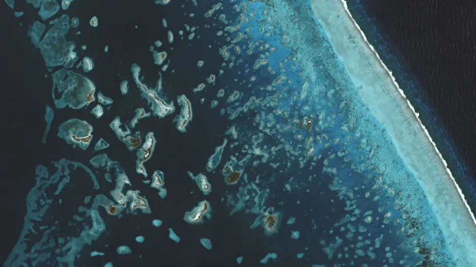
Coral reefs off the coast of Belize, imaged by Planetscope in 2019.
The world’s coral reefs mapped from space
The Allen Coral Atlas, a global map and analysis of the world’s shallow coral reefs was completed last year with almost 2 million images taken from Earth’s orbit. It’s an incredible tool for the conservation and monitoring of the world’s coral reefs and it is free and accessible online.
The Atlas is managed by Arizona State University’s Centre for Global Discovery and Conservation Science in partnership with the Earth-observation company, Planet, the University of Queensland, a network of coral reef scientists, and many other entities. The map consists of a mosaic of high resolution Planetscope satellite images which have been processed to remove unwanted artifacts such as clouds. The reef images are then characterized automatically, pixel by pixel, through machine learning. The result is an easily navigable digital map of pristine images of all Earth’s shallow reefs which also provide information about the distribution, structure and morphology of the reefs, and the types of species and sediment present. To be confident in the Atlas’ results, a network of scientists working on the ground and in the water validate the interpretations made from above.
Conservation of the world’s coral reefs is of great importance. Reefs protect coastlines from the wave action of storms and erosion and they provide habitats and shelter for marine organisms, including thousands of fish which are part of a larger ecosystem. They are a source of food and medicines, and they provide jobs for local communities and are essential to many tourist economies. Unfortunately, our reefs are threatened by climate-related warming seas, pollution, overfishing, as well as physical damage due to coastal development and poor fishing practices.
The Allen Coral Atlas is supporting a variety of initiatives directed at the protection, restoration and conservation of the world’s coral reefs and marine species, and assisting in the management and policies related to coral reefs. For example, local governments can prohibit fishing temporarily in regions where a reef is struggling.
Warning signs of a struggling coral reef can be observed from space. Coral bleaching ― a whitening of coral caused by the expulsion of symbiotic algae due to elevated water temperature ― will be evident as a change in colour. Turbidity, shown as a change in brightness, is a sign that the reef’s filter feeding corals and sponges are not well, as they commonly clean the water. Alerts for these phenomena have been integrated into the Atlas to notify scientists that a reef is unhealthy so they can take corrective action.
By Cassandra Marion
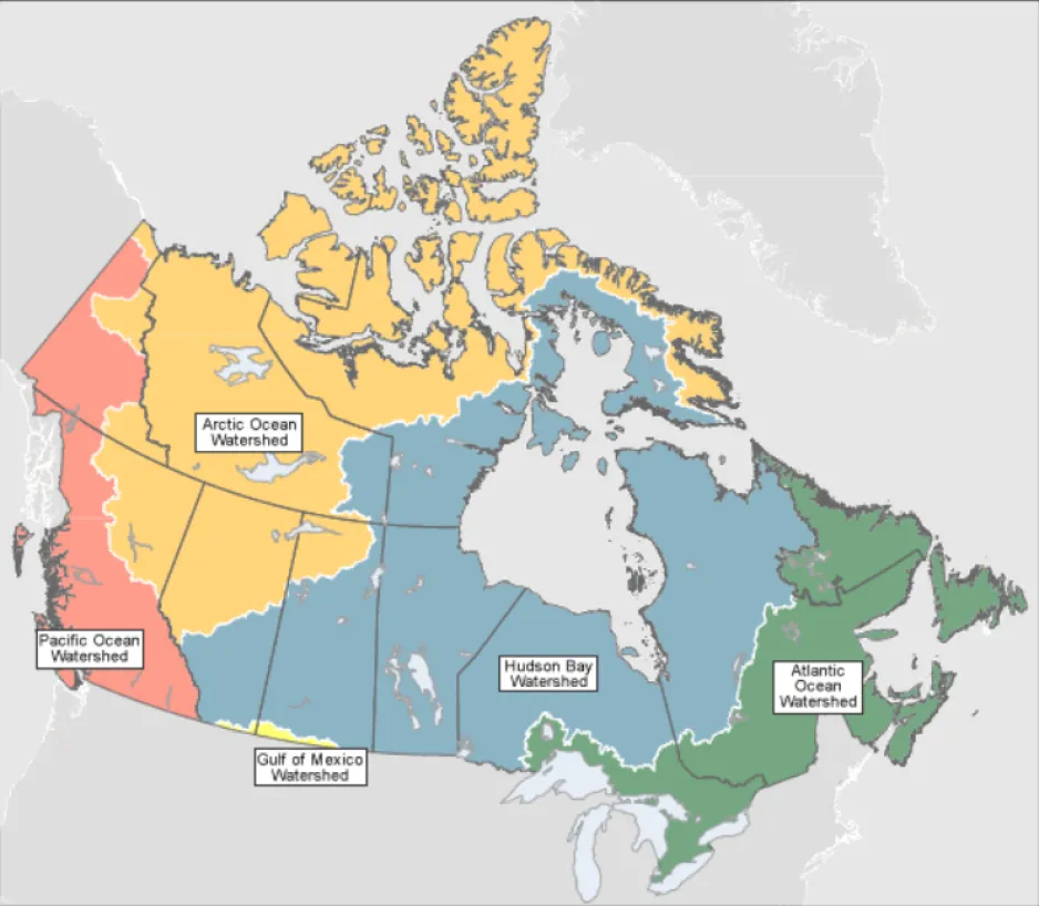
Canada has five ocean watersheds, each represented by a different color on this map
All rivers run to the sea…but which one?
When rain falls or snow melts, the water finds its way to the ocean. The routes are variable. Some water runs over the ground into lakes and along streams. Some water soaks into the soil, flowing underground before emerging again. Some water falls on city streets, pours into drains, and runs through sewers before joining natural water ways. However it happens, water that falls on land eventually joins a creek, stream, or river, and follows it to an ocean.
But which ocean? In Canada we are surrounded by three: the Atlantic to the east, the Pacific to the west, and the Arctic to the north. So, if you were to pour out a bucket of water in Calgary, Ottawa, or Yellowknife…which ocean would that water eventually end up in?
The answer is determined by which watershed you are in. Despite the name, a watershed is not a building where one keeps water. It is an area of land, and any water that falls on that area of land will eventually reach the same destination. Think of it like a bathtub. Regardless of where you pour a cup of water in a bathtub (the front, the back, the sides…), all water eventually goes down the same drain.
The size of a watershed (also known as a catchment or drainage basin) can be defined at a small scale– e.g., all the land that drains into a particular pond; or a large scale- all the land that drains into an ocean.
In Canada, we have five ocean watersheds:
- The Pacific Ocean Watershed west of the Rocky Mountains
- The Arctic Ocean Watershed which encompasses most of the Territories, and northern Saskatchewan, Alberta, and BC
- The Hudson Bay Watershed is our largest watershed, extending over five provinces from Quebec to Alberta, and also over parts of Nunavut and the Northwest Territories.
- The Atlantic Ocean Watershed is formed by the maritime provinces, plus southern Quebec and Ontario
- And finally, the Gulf of Mexico Watershed. A small area on the southern border of Alberta and Saskatchewan drain into the Mississippi river system, which flows south all the way to the Gulf of Mexico.
In Canada, we are very much an ocean nation. For those living with no direct contact to the oceans, it can be hard to remember that. Yet, across our immense country, water from millions of kilometers of streets and fields and forests flows into thousands of rivers that eventually drain into our oceans. As that water flows, it often picks up pollutants, which can have terrible effects on the ecology of the watershed, and ultimately, the ocean where it ends up.
What can we learn from watersheds? In a watershed, all water is connected, flowing into a single body of water. People are also connected by watersheds, and our decisions and actions have the potential to impact the quality of the water we all depend on. By working together, we can make sure that we can depend on our waterways indefinitely.
GO FURTHER:
- Five easy ways to protect your local waterways
- Health and threats of Canada’s watersheds
- Learn more about how watersheds work
By Michelle Campbell Mekarski
Enjoying the Ingenium Channel? Help us improve your experience with a short survey!


